Namibia has made great progress in the fight against malaria. For complete elimination, however, health officials need better data on how infected people move between communities to understand transmission dynamics. Ongoing Flowminder work led by Professor Andy Tatem, in collaboration with the National Vector Borne Disease Control Program, the Clinton Health Access Initiative (CHAI) and Mobile Telecommunications Limited (MTC) is helping achieve this through a combination of malaria case data, satellite imagery and anonymised mobile phone records.
Satellite imagery is used to map the environmental conditions in which malaria parasites and mosquitos are abundant, and cell phone records are used to anonymously track population movements. Together, the two types of data allow detailed mapping of malaria transmission in Namibia, and allow interventions like indoor spraying with insecticide to be targeted optimally to disrupt the malaria transmission cycle.
Moving from Reducing to Eliminating Malaria
Between 2004 and 2011, annual malaria cases in Namibia dropped 98%, from over six hundred thousand to just 14,400. To completely eliminate the disease, health officials must now locate isolated cases, a challenging task that lies beyond the capability of current data systems.
The Geographic Causes of Malaria Risk
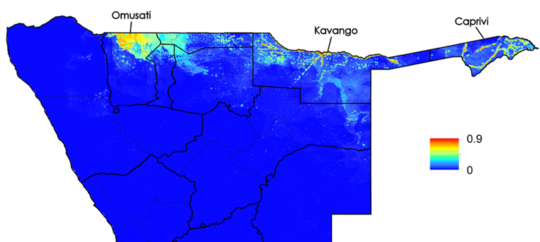
Using satellite images, Flowminder researchers constructed maps of environmental factors like vegetation density, population, and rainfall that affect mosquito and parasite populations and the likelihood of transmission. Linked with reliable malaria case data from surveillance systems, this information was then used to infer risk of malaria infection at high spatial resolution throughout northern Namibia.
Malaria transmission suitability map built from geolocated case data and satellite imagery

Mapping Mobility with Anonymised Cell Phone Records
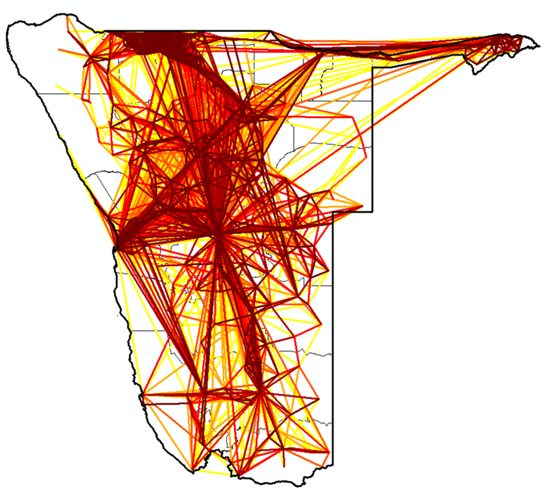
As infected people move between communities, they carry the malaria parasite in their blood. To reconstruct travel patterns, Namibia’s largest network provider, Mobile Telecommunications Limited (MTC), provide ongoing access to anonymized cell phone records of over 2 million users. As calls are made, the location of the cell towers through which signals pass is recorded. Call frequencies and locations then allow Flowminder researchers to create detailed maps of human movement (see below).

Principal population movements over the course of one year in Namibia, derived from anonimised mobile data
Targeting Interventions
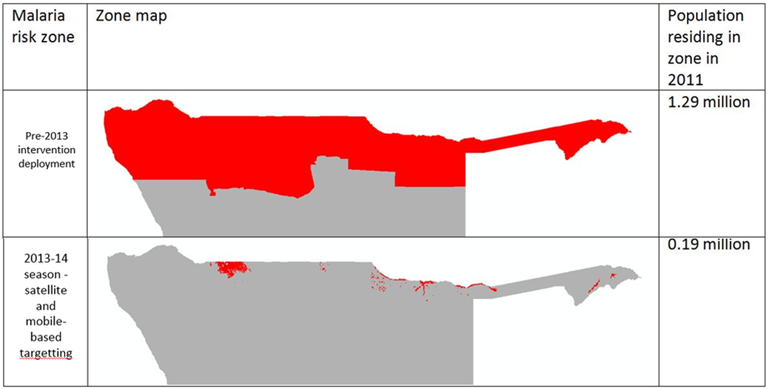
In 2013, Namibia’s Ministry of Health, supported by the Global Fund and CHAI, used the Flowminder mobility and malaria risk maps to target bed net distribution and indoor insecticide spraying to key areas. Instead of the daunting challenge of immediately covering 1.2 million people – the previous estimate of the population at highest risk of malaria – the health system used its limited resources to first reach the 80,000 people most important to the malaria transmission cycle, as defined by the Flowminder maps (see below).
Refining malaria intervention targeting through combining satellite, mobile and malaria case data

Improving Surveillance, Mapping Foci and Post-Elimination Planning
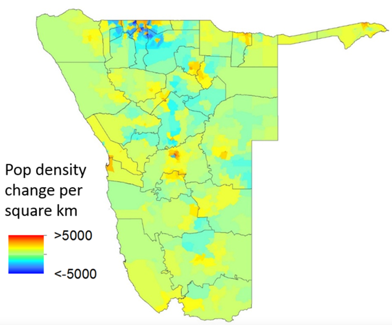
On-going Flowminder work in Namibia continue to provide malaria elimination support in Namibia. The development of dynamic population mapping methods from anonymised mobile data has facilitated the construction of monthly population density maps from 2010 to the present day (see below), providing unique insights into changing health facility catchment sizes, and their influence on estimates of incidence through changing denominators. This is aiding in the development of refined measures of monthly malaria incidence. Moreover, incorporating population movement patterns derived from mobile data into malaria risk mapping is enabling the identification of regions where transmission is likely being sustained through the introduction of infections from elsewhere, guiding effective targeting of interventions to transmission foci. Finally, the improved understanding of population movement patterns is enabling Flowminder researchers to simulate the risks of malaria outbreaks in post-elimination scenarios, providing guidance on where increased surveillance may be necessary.

Population density change estimates per 1x1km grid cell for January to February 2011
