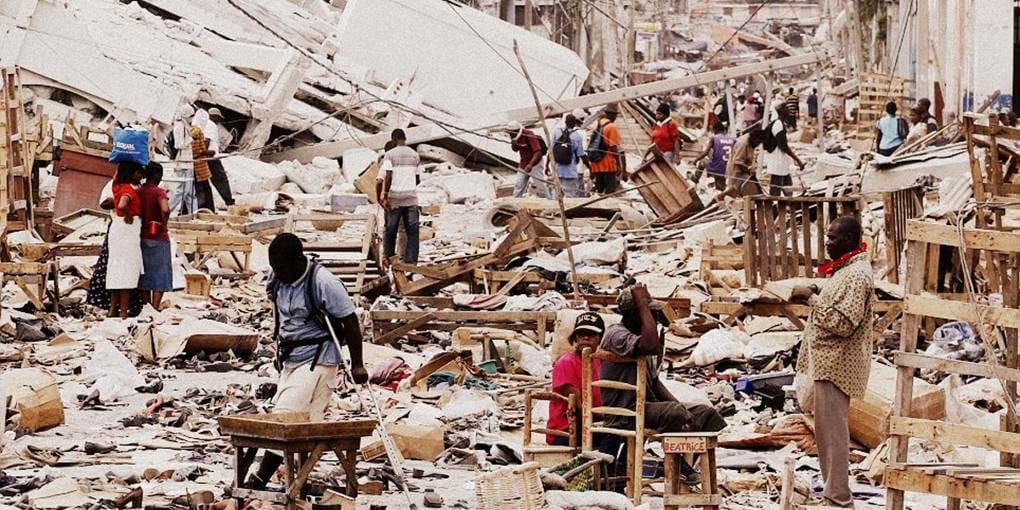
The researchers behind Flowminder in collaboration with Digicel, the largest mobile phone operator in Haiti, pioneered the use of anonymous mobile operator data to follow population movements after the tragic 2010 earthquake and cholera outbreak in Haiti. The Flowminder team analysed the movements of two million anonymous mobile phones in Haiti, providing critical support to the UN and other relief agencies.
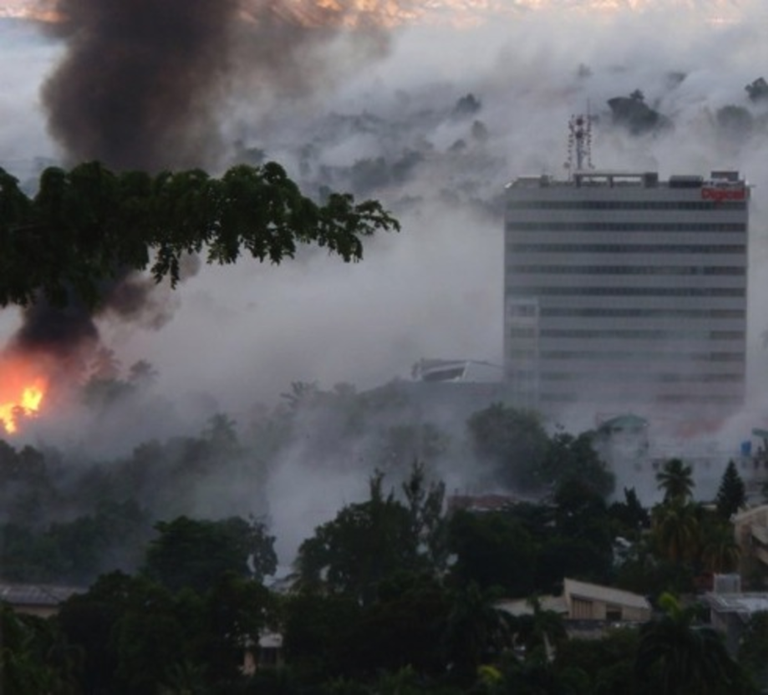
The team subsequently showed in academic research that these mobile phone movements corresponded closely to the real mobility of the population after the earthquake. The team also showed how general population mobility before the earthquake could be used to predict post-earthquake population displacement patterns, providing the crucial opportunity to prepare relief activities before disasters strike.
On average there is a disaster displacing more than 100,000 people every second week somewhere on earth. There is, on average, a natural disaster displacing more than 1,000,000 people every second month¹.
During large disasters and crises there is a severe lack of basic information on the locations of affected people. This prevents relief organisations from delivering the right amounts of supplies to the right places, even when sufficient resources are available.
Photo credit: David Sharpe

Photo Credit: The Joshua Fund
Available methods to understand where people are moving include counting people by the road, registering people who come to camps and looking at satellite or aerial images. All these methods are unfortunately difficult to implement or highly inaccurate. Counting moving people on the ground is extremely difficult. People are often spread out over thousands or hundreds of thousands of square kilometers and it simply becomes impossible to prepare for, distribute, support and try to aggregate information from these people under emergency conditions. Camps unfortunately come up late during an emergency, often when help has already become available. Most people also avoid camps, preferring to stay with host families and frequently ending up in urban slums. Most people move inside vehicles or stay in houses or under vegetation. Static images also make it impossible to know if people are simply moving back and forth short distances or moving away in a single direction.
The earthquake struck Haiti in the afternoon at 16:53 local time, causing widespread panic and chaos. As with many other large disasters before, large numbers of people started leaving the capital but very little was known about the numbers and the places they were heading. Relief goods were coming into Port-au-Prince but beyond this no reliable information was available to understand where people displaced by the earthquake were located.
Dr. Bengtsson, executive director and co-founder of Flowminder, realized that that anonymized data from mobile phone operators in Haiti potentially could provide the answer to the questions sought by relief agencies. He contacted the two operators active at the time, Digicel Haiti and Voila. Only the former replied but that reply was going to mean a turning point in the support of displaced populations globally. The CEO of Digicel Haiti, Maarten Boute, in collaboration with Head of Products and Pricing David Sharpe, had lived through the earthquake and clearly understood the value of the data they stored. After careful discussions about data safety, anonymization and a strict legal framework, Maarten Boute gave the go-ahead for Dr. Bengtsson and his colleagues at Karolinska Institute to analyse the data and distribute the analyses, while David Sharpe led the project from the Digicel side.
Xin Lu, computer scientist with a Ph.D. in Public Health from Karolinska and co-founder of Flowminder, coded the analyses. After data cleaning and filtering, the total dataset came to consist of 1.9 million SIM cards occurring in 282 million registered calls. At the time, the ratio of SIM cards to the adult population in Port-au-Prince was 50%.
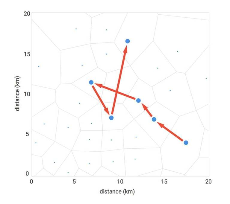
"The analysed data are called Call Detail Records (CDRs), and they come in standardized format as defined by industry association of operators, GSMA. It contains for each call, a record the ID of the mobile phone tower used to route the call. The data thus makes it possible to know within which tower coverage area an anonymous user was located at the time of the call. By looking at the aggregated patterns of these movements, large-scale population movements can be analysed."
The research team led by Dr. Bengtsson distributed a number of reports to relief agencies throughout 2010, providing up to date information on where people were located and how they eventually were returning to Port-au-Prince. For relief agencies, this data was crucial. The International Organisation of Migration was the lead agency for understanding the displacement situation. Damien Jusselme, Information Management Unit, IOM, wrote the following about the displacement reports in 2012:
From 2010 up until now, the "Digicel Studies" remain the only exhaustive report on the movement of population outside of the earthquake affected-area. It was widely used in 2010 and 2011 to advocate for a more important focus on this population that fled the capital right after the earthquake to be hosted by families and communities outside of the affected area [...] it provided us with the necessary figures to advocate with donors and to coordinate the response in the regions. [...] it is a revolutionary toolthat should be generalized for further emergencies involving major displacements.
Damien Jusselme, Information Management Unit, IOM,
Minustah Logistic Base, Port-au-Prince, Haïti
When the devastating cholera outbreak struck ten months after the earthquake, the team was prepared and could rapidly distribute analyses of how people were moving from the outbreak area, analyses which subsequently were shown in academic work to predict the spread of the epidemic.
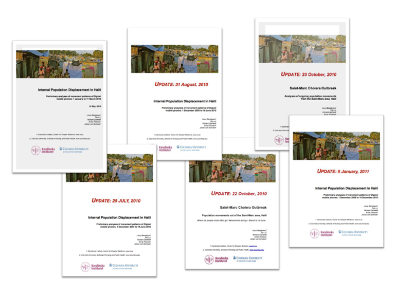
So what did the analyses show?
An estimated 630,000 people left Port-au-Prince after the earthquake. The estimated decrease of the PAP population size was 20%.
Changes in the number of mobile phones inside Port-au-Prince compared to the number present in Port-au-Prince on December 21st, 2009
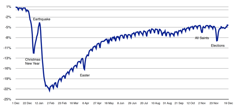
The crucial assumption made in the analyses above is that the movements of the mobile phones in Haiti were representative of the movements of the population. This did, however, not necessarily need to be the case as phone use is low or non-existent among children and the elderly, as well as lower among poor than among the rich.
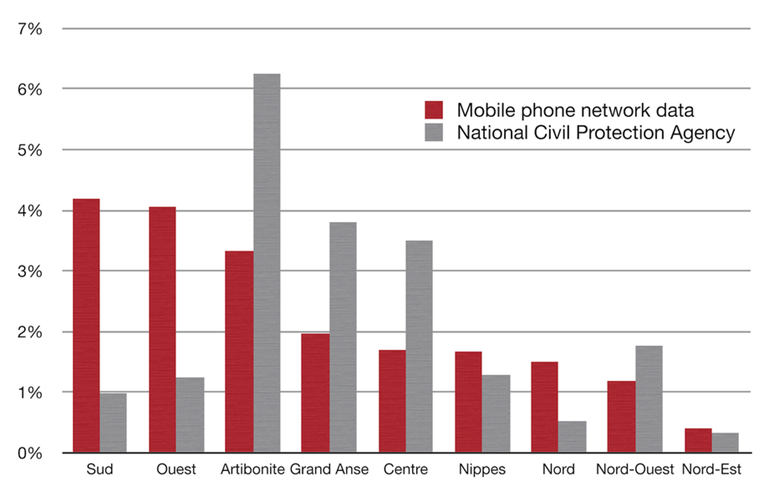
A year after the earthquake struck, the research team started the academic work on the data, published in PLoS Medicine in 2011. The team first compared the results from the mobile phone analyses with the reports based on data from government in collaboration with the UN. These analyses were widely used by most large relief agencies in Haiti. Notably when comparing the two data sources, there was no correlation between the two.
'The proportion of the Port-au-Prince population leaving Port-au-Prince for the Haiti Departments (provinces) around the country. Red shows mobile phone network data. Grey shows numbers reported by the National Civil Protection Agency. No correlation can be seen.'
In collaboration with UNFPA in Haiti the team could however compare the distributed analyses with the results from the agency's city-wide survey, performed seven months after the earthquake. The UNFPA study included a representative sample of x households in PaP, including questions on who had left the PaP after the earthquake and where they had travelled to. The high correlation to the mobile data analyses previously distributed by the research team is clear. More work remains to be done in diverse contexts to understand the representativeness of the data and how to best adjust estimates to match the true population movements. However, these first results were a milestone in the development of new analysis methods in humanitarian response.
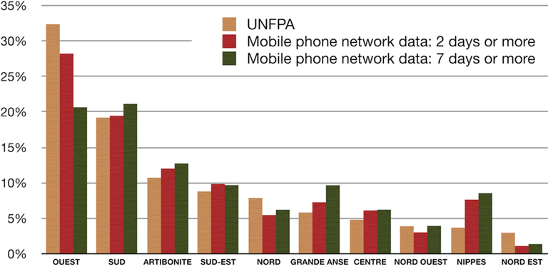
'Among the people who had left Port-au-Prince after the earthquake, the graph shows the proportion going to the various departments (provinces) in Haiti. The beige bars show the results of the UNFPA (United Nations Population Fund household survey. The red bars show the proportion of the mobile phone subscribers leaving Port-au-Prince for at least two days and the green bars the proportion leaving for at least a week.'
Predicting Displacement
Response to disasters is important, but even more so is preparation. The next step in the research was to develop methods of how data from before the earthquake could predict where people actually went afterwards. Xin Lu, Linus Bengtsson and collaborator Petter Holme at Umeå University in Sweden found important regularities in the movement patterns of the population. One of the important findings was that out of the people leaving Port-au-Prince during Christmas and New Year before the earthquake, the place they returned to after the earthquake was often the same. While it makes that people return to where they have friends and family, the finding opens up for a completely new way of predicting population movements that will follow after crises: find out how people in different areas are connected by travel and communication patterns, especially during important family occasions and use these patterns to predict aggregate population movements that will occur after a disaster strikes.
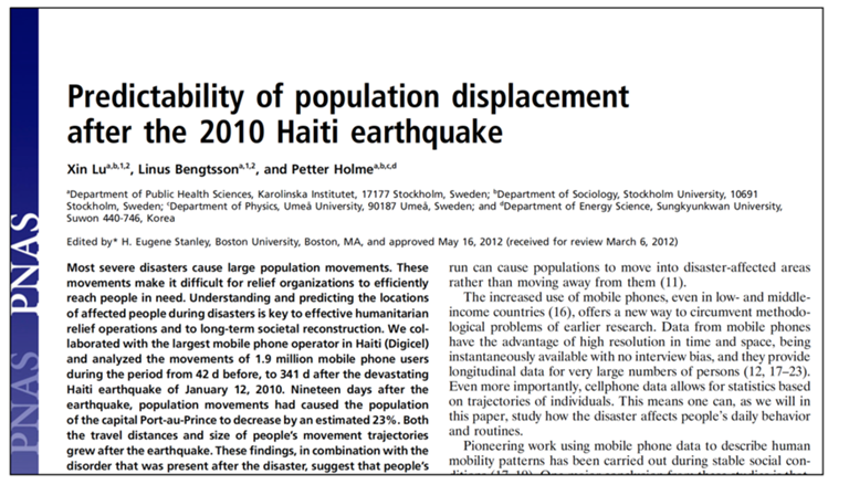
Research on the predictability of population displacement published in the Proceedings of the (US) National Academy of Science (PNAS)
Scaling and Improving the Work
Flowminder works in a number of countries to scale and develop these methodologies, including performing household surveys to develop methods suitable for diverse settings.
Understanding what areas are at risk for disasters is also paramount to making a difference. Nepal, and Kathmandu in particular, have been rated as the most high-risk areas for a devastating earthquake for many years. Half a year before the 2015 earthquake, Flowminder and the Nepalese operator Ncell initiated a joint program of work to be able to respond in the event of a major earthquake. The team started preparatory work in Nepal one week before the 2015 earthquake. This came to be the second time that anonymous mobile operator data was used during a major humanitarian crisis.
¹. Displacement due to natural hazard-induced disasters, report by Internal Displacement Monitoring Centre, Geneva.
